
Flood Risk Due to Ice Jams and Estimation of Winter River Flows in a Climate Change Context
The project raised awareness among water managers about the problem of ice jam flood risk. This initial analysis helped better define the issues and guide the search for relevant adaptation measures.
Project details
Principal(s) investigator(s)

Context
Flooding along Québec’s rivers is not only due to open water floods, like that of May 2017. It is also caused by ice jams that block rivers, causing them to overflow their banks. Ice jams can occur during ice breakup in winter (e.g. January 12, 2018 and January 22, 2018) or spring (e.g. March 21-23, 2013 and April 15-16, 2014), when the ice cover breaks and moves downriver as a result of increased flow due to rainfall or rapid snowmelt.
Climate change is expected to increase the frequency of winter thaw events and consequently amplify flow variability and change the ice regime of watercourses. In some regions, these changes can lead to more frequent ice movement resulting from greater water flow, increasing the risk of ice jams that may obstruct the watercourse. In others, reduced ice cover thickness or even the absence of ice could lead to a reduction in the frequency of ice jams.
The damage caused by ice jam flooding can represent significant costs and consequences, and this risk could increase in the future under climate change. However, there is a lack of knowledge and tools to better understand and quantify this phenomenon.
Objective(s)
Quantify the change in frequency and risk of ice jam flooding in a climate change context.
Methodology
-
Identify watercourses in different regions of Québec that are subject to ice jams;
-
Develop a model for ice breakup leading to ice jams for each identified watercourse;
-
Analyze historical meteorological and hydrological data to quantify the frequency of ice jam flooding during the period 1972-2000;
-
Use reported damage data to estimate the magnitude of ice jam flood risk during the same period;
-
Identify possible climate scenarios and extract relevant meteorological and hydrological data for the period 2040-2070;
-
Use the same models to evaluate future ice jam flood frequency and risk;
-
Compare past and future and make recommendations to better monitor and manage this phenomenon and its possible evolution.
Results
Using meteorological and hydrological analyses along with climate scenarios, the project quantified the damage caused by ice jam flooding and produced simulations for evaluating future risk
On the 9 rivers analyzed for the historical period 1972-2000:
-
About 550 breakups causing ice jams occurred, for an average of 2 significant breakups per year, per watercourse.
-
50% of floods and 50% of flood damage reimbursed by the Ministère de la Sécurité publique were associated with ice jams.
-
Average damage associated with ice jams is $3.2 million per year
On 7 rivers analyzed in a climate change context for the 2042-2070 time horizon (Figure 1):
-
The winter period and the period with a non-zero probability of ice breakup will be shorter.
-
ce jam flood frequency and risk will decrease, remain stable or increase (significantly in some cases) depending on the watercourse and the region.
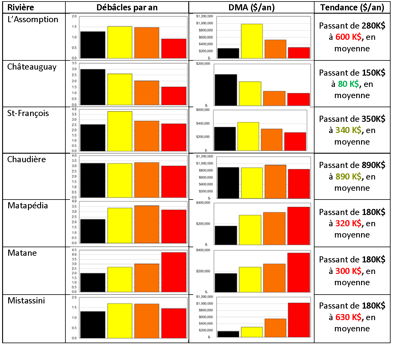
Figure 1 : Table summarizing trends in the frequency of dynamic ice breakup and average annual damage associated with ice jam flooding in a climate change context for 7 Québec rivers. The historical data is shown in black. The 9 climate change scenarios are grouped into optimistic scenarios (yellow), median scenarios (orange) and pessimistic scenarios (red).
The results obtained show that in some cases, more specifically in rivers in southern Québec, ice jam flood risk could decrease as winter temperatures rise, simply due to a lack of ice to form ice jams. In other cases, including the Saint-François and Chaudière rivers, a reduction in the quantity of ice and a shorter winter period would be offset by a higher frequency of high flow events causing dynamic ice breakup and ice jams. Flood risk is therefore more or less constant under different climate change contexts.
Finally, along several watercourses located in Québec regions from Lanaudière to Gaspésie and Lac-Saint-Jean, a greater frequency and intensity of winter and spring floods would increase ice jam flood risk, sometimes significantly.
Recommendations
-
Raise awareness among water stakeholders about ice jam flooding and anticipated trends.
-
Develop mitigation measures (structural intervention, preventive weakening of ice cover, flow management, flood-proofing, adaptation of the legal framework, inclusion of ice jam flooding in the definition of flood zones, development of intervention protocols in the event of major flood events) to reduce risk.
-
Use and promote the flood forecasting models developed and calibrated as part of this project, possibly in collaboration with the Ministère de l'Environnement et de la Lutte contre les changements climatiques and the Ministère de la Sécurité publique.
-
Continue to study the impact of climate change on winter hydrology and ice processes.
-
Develop knowledge.
-
Ensure proper training for the next generation.
Benefits for adaptation
The project raised awareness among water managers about the problem of ice jam flood risk.
This initial analysis helped better define the issues and guide the search for relevant adaptation measures.
Scientific publications
Funding
Other participants
-
Ministère de la Sécurité publique (MSP)
-
Ministère du Développement durable, de l’Environnement et de la Lutte aux Changements Climatiques (MDDELCC)