
Reducing Vulnerability to Flooding and Erosion Related to Climate Change for Communities Along the Fluvial Section of the St. Lawrence
The knowledge developed by the project has provided riverside municipalities with a better understanding of the processes related to riverbank erosion, allowed them to identify areas that are vulnerable to this hazard, and provided a portrait of the possible evolution of flooding and erosion under climate change.
Project details
Principal(s) investigator(s)

Context
Coastal and riverside municipalities along the St. Lawrence are exposed to fluctuations in water levels and shoreline erosion, the frequency and intensity of which are affected by climate change. These hazards threaten riverbanks, coastal ecosystems, infrastructure and buildings, as well as population safety.
This project is part of the « fluvial section » component of Action 2.6 of the Quebec Climate Change Action Plan 2013-2020 (PACC), which aims to respond to the concerns expressed by municipalities.
It is based on a close collaboration with the organizations coordinating the TCRs in the targeted area and with the teams involved in two other projects included in the same component of Action 2.6. One of these, led by Patrick Lajeunesse of Université Laval, focuses on the characterization of riverbanks and the assessment of erosion-related vulnerabilities. The other, led by the Direction de l'expertise hydrique et atmosphérique (MELCC), concerns the evaluation of areas vulnerable to water level fluctuations in current and future climate.
Objective(s)
-
Document the probable evolution of the main hydro-climatic factors that influence the natural risk of water level fluctuations and erosion processes;
-
Work in close collaboration with community stakeholders throughout the project to clearly understand all issues related to these two hazards and to identify the communities' requirements to better adapt to the risks of riverbank erosion and flooding and their evolution in relation to climate change.
Methodology
-
Analyze the historical natural variability and document future trends (2050, 2080) of the main hydro-climatic factors that influence water level fluctuations and riverbank erosion processes along the fluvial section of the St. Lawrence;
-
Interact regularly (meetings, workshops) with regional stakeholders through close collaboration with the regional bodies responsible for coordinating TCRs: present the findings of the projects of the « fluvial section » component of Action 2.6, discuss the issues and identify the communities' requirements to adapt to the risks of riverbank erosion and flooding;
-
Develop links between the three project teams to optimize the exchange of information and coordinate links with regional stakeholders (requests for information, presentation of findings).
Results
Several hydroclimatic factors influencing erosion and flooding processes along the fluvial section of the St. Lawrence were identified, including flooding related to spring runoff or sea level rise and submersion in tide-influenced areas
An analysis of MERRA-2 historical data, combined with a literature review, led to the conclusion that the flooding of 2017 was due to exceptional quantities of water (particularly rain and rain-on-snow) (Figure 1).
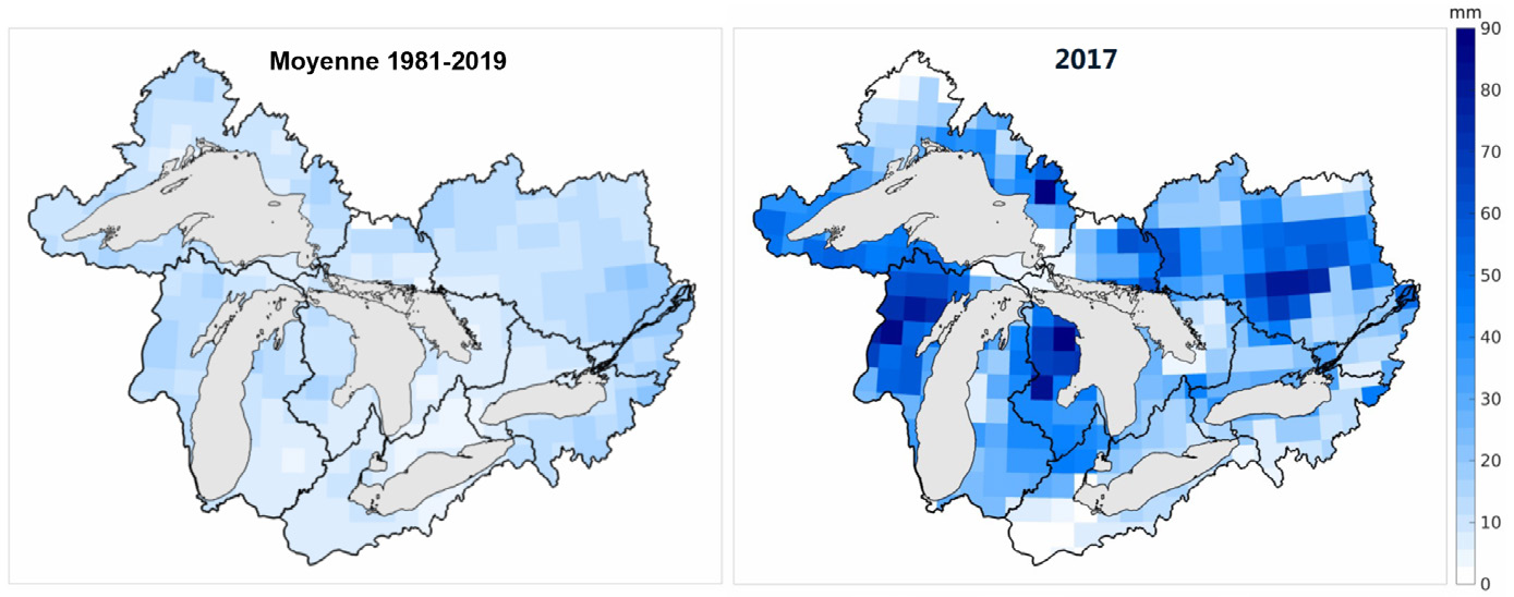
Figure 1. March to June rain-on-snow amounts (mm) over the Great Lakes / Ottawa River watershed from the MERRA-2 reanalysis.
These high water levels typically occur as a result of a warm and wet spring combined with a near- or above-average amount of snow on the ground. On the other hand, the flooding in 2019 appears to have been caused instead by record amounts of snow combined with synchronized thawing of several watersheds. The complexity of the St. Lawrence River watershed, anthropogenic management of flows and water levels, and the transition to a system with less snow but more rain, makes it difficult to estimate the impact of climate change on flooding. Rather, the important message is that a change in the water regime is to be expected and that flexibility in the river’s management will be required, especially during the transition to a significantly warmer climate.
Few strong trends are observed for storms causing flooding, but the gradual disappearance of shore ice, as well as sea level rise, could exacerbate the impact of this phenomenon on the shoreline.
The stakeholders consulted identified many needs for adapting riverside communities to the risks of riverbank erosion and flooding, including physical solutions (e.g. regional intervention plans based on a concerted and coordinated approach, a portfolio of locally adapted solutions to stabilize riverbanks, including bank revegetation or wetland maintenance/restoration), decision support tools (e.g. mapping flood zones and zones at risk of erosion, a technical compilation of solutions), institutional mechanisms (e.g. funding for municipalities to implement solutions, revision of the regulatory framework), as well as actions to raise awareness or educate elected officials, municipal professionals and citizens.
The action 2.6 of the 2013-2020 PACC has addressed some of these needs. The project led by Université Laval characterized the river banks along the entire length of the fluvial section, mapped the areas most vulnerable to erosion, and identified the erosion processes involved.
Benefits for adaptation
The knowledge developed by the project has provided riverside municipalities with a better understanding of the processes related to riverbank erosion, allowed them to identify areas that are vulnerable to this hazard, and provided a portrait of the possible evolution of flooding and erosion under climate change.
The data and tools developed by Université Laval will help them manage the risks of erosion through better planning and development. They will also provide input for the regional integrated management plans developed by the stakeholders of the four Regional Round Tables (TCR) of the fluvial section of the St. Lawrence.
Finally, the needs identified by local stakeholders will support government policy on population safety, land use planning and environmental protection. They will also help guide research and development programming.
Scientific publications
Tous les livrables finaux des projets réalisés dans le cadre de ce projet par Ouranos et l’Université Laval sont disponibles pour téléchargement sur les sites de Données Québec de l’Observatoire global du Saint-Laurent (OGSL)
Funding
Other participants
-
Ministère de l’Environnement et la Lutte contre les Changements Climatiques (MELCC)
-
Université Laval
-
Organizations responsible for coordinating the Regional Round Tables (TCR) of the fluvial section of the St. Lawrence : the Lac Saint-Pierre, les Deux-Rives, Jacques-Cartier, Haut-Saint-Laurent, Des Seigneuries ZIP Commiteeds and the Québec Metropolitan Community ZIP Commitees