
Modeling of Future Water Temperature Scenarios in Coastal Environments and Implications for Potential Infection by Vibrio Parahaemolyticus and Vibrio Vulnificus
The projections from the project serve to identify plausible risks and protect human health and the shellfish industry in the Estuary and Gulf of St. Lawrence.
Project details
Principal(s) investigator(s)

Context
Vibrio vulnificus and Vibrio parahaemolyticus are zoonoses associated with the consumption of shellfish. These bacteria are extremely sensitive to variations in temperature. As a result, anticipated temperature increases over the coming decades could have a positive impact on their proliferation.
Shellfish harvesting remains an important recreational and commercial activity for Québec. However, some harvesting areas (Côte-Nord, Gaspésie, Bas Saint-Laurent, Prince Edward Island) could be more at risk, due to changes in water temperatures.
Objective(s)
Adapt a statistical model (artificial neural network) to water temperature in environments that are home to large shellfish beds open for harvesting, in order to:
-
Verify the performance of the model at the surface and in deep water;
-
Identify the best predictors of coastal water temperature; generate future coastal water temperature scenarios;
-
Map zones at risk for proliferation of Vibrio vulnificus and Vibrio parahaemolyticus;
-
Cross-reference risk areas with shellfish bed sites.
Methodology
-
Adapt a machine learning model to coastal water temperatures. Select and calibrate the model using historical meteorological data and sea surface temperature series in the target areas;
-
Transfer the information to shallow areas based on temperature measurements taken over the shellfish beds during the project;
-
Generate past and future thermal scenarios using the outputs from climate models provided by Ouranos. Develop a map of risk areas.
Results
The figures below show an example of the distribution of the number of days that exceed the threshold temperature for infection risk (15°C) for surface waters (mean depth 1.5 m) in the Estuary and Gulf of St. Lawrence in August (the hottest month) for two climate change scenarios: optimistic (RCP4.5) and pessimistic (RCP8.5) and two time horizons (2040-2060) and (2080-2100). It can be seen that in both scenarios, the shellfish beds off the Magdalen Islands, Prince Edward Island, the Gaspé Peninsula, Baie des Chaleurs, and part of Côte Nord will be at a high risk of infection by vibrio.Indeed, the number of days above the 15°C threshold varies between 25 and 31.
During the period 2040-2060, the surface area over which the threshold is exceeded for 25 to 31 days increases from 65% under the optimistic scenario to 72% under the pessimistic scenario. The surface area over which the 15°C threshold is exceeded for less than 10 days varies between 4% and 5% under both scenarios.
By 2100, the area over which temperatures exceed 15°C for more than 25 days accounts for 98% of the surface area of the Estuary and Gulf of St. Lawrence in the pessimistic climate scenario, and 72% in the optimistic scenario.
On the other hand, the area over which temperatures exceed 15°C for less than 10 days accounts for 3% of the total surface in the optimistic scenario and becomes negligeable in the pessimistic scenario. As shown in the figures, the risk of vibrios infection increases significantly under both climate change scenarios studied for shellfish beds off the Magdalen Islands, the Gaspé Peninsula, Baie des Chaleurs and part of Côte Nord. This risk increases spatially, covering new areas as we approach 2100.
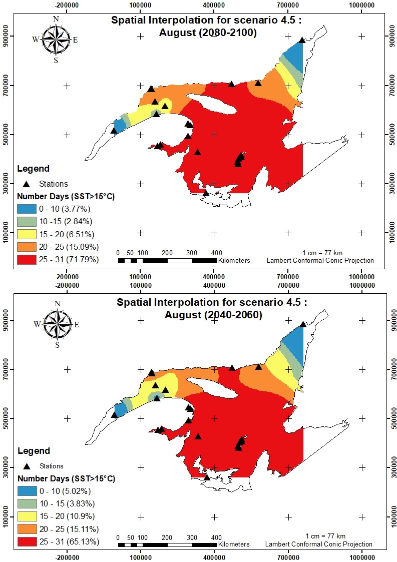
Figure 1. Interpolation maps for the infection risk indicator in the St. Lawrence Estuary in an optimistic scenario (RCP4.5) during the month of August
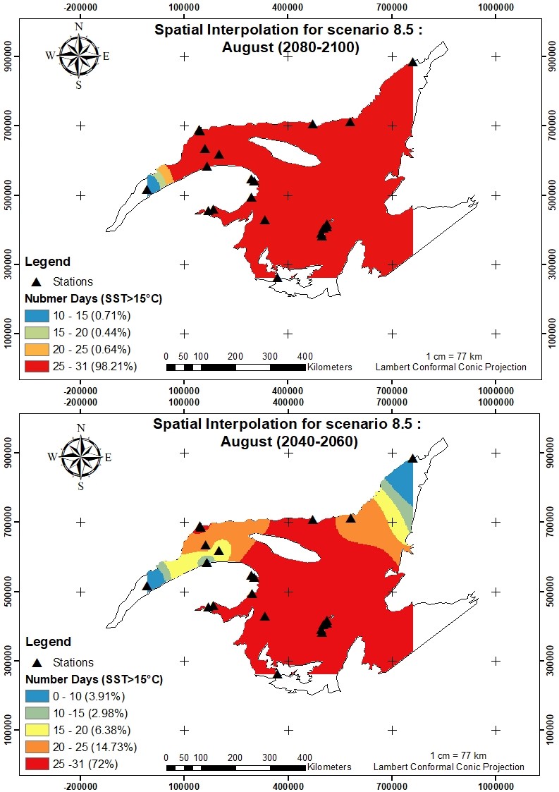
Figure 2. Interpolation maps for the infection risk indicator in the St. Lawrence Estuary in a pessimistic scenario (RCP8.5) during the month of August
Benefits for adaptation
Benefits for adaptation
The projections from the project serve to identify plausible risks and protect human health and the shellfish industry in the Estuary and Gulf of St. Lawrence.
They could be used either to locate the safest areas for shellfish harvesting or to implement risk measurement measures, such as increasing the frequency of water quality and temperature measurements, as well as more frequent sampling of cultivated or harvested shellfish for microbiological analysis.
Scientific publications
Funding
Other participants
-
INSPQ
-
MÉRINOV