
The new data on rising sea and ocean temperatures all over the planet is an indicator of the climate change that is underway. In particular, this influenced the Atlantic hurricane season, which started very early this year and has been very intense to date, despite the return of the El Niño phenomenon.
Ocean warming: Tangible proof of climate change
Increasing ocean temperatures, a trend that has already been on the rise for decades, are tangible proof that global warming is occurring. In early September, the European climate service Copernicus confirmed that not only were July and August the hottest months on record for the planet, but that the oceans had also set new records. On August 31, 2023, the average sea surface temperature reached the unprecedented, symbolic high of 21°C.
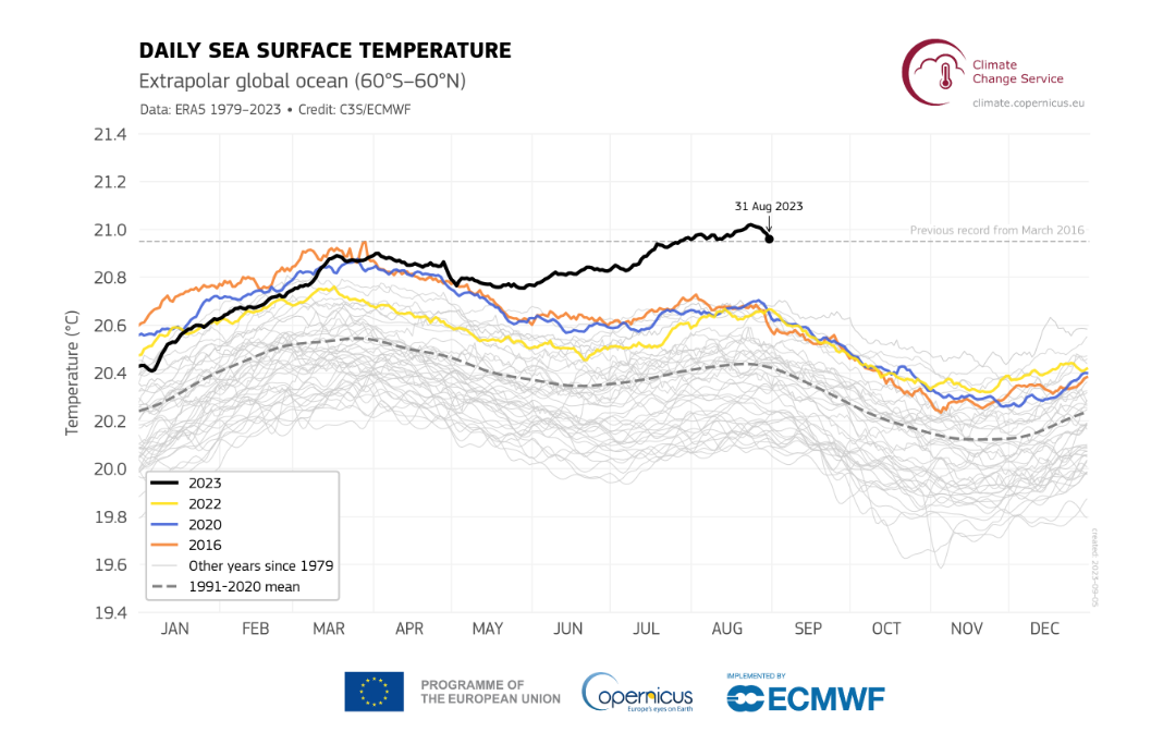
Figure 1: Daily sea surface temperature (°C) averaged over the extrapolar global ocean (60°S-60°N) in 2023 (black line) and in 1979-2022 (grey lines). Average conditions for 1991-2020 are represented by the dotted grey line. The previous global average sea surface temperature record from March 2016 is indicated by the dashed horizontal grey line (from: Copernicus, 2023b).
Oceans, which cover more than 70% of the Earth’s surface, play a crucial role in regulating the global climate. In fact, the oceans absorb 93% of the Earth’s available energy. For one thing, they are known to absorb great quantities of carbon dioxide (CO2) from the atmosphere, thus acting as an essential carbon sink. They also act as thermal reservoirs, storing a large amount of the sun’s heat. These crucial functions help maintain our planet’s climatic equilibrium.
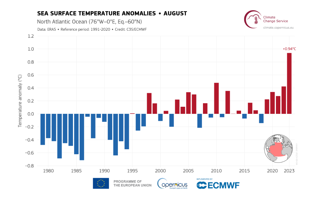
Figure 2 : Sea surface temperature anomalies (°C) averaged over the North Atlantic for the month of August, from 1979 to 2023 (from: Copernicus).
However, with increasing greenhouse gas emissions from human activities, the oceans are no longer able to fulfill their carbon regulation function. As a result, their temperatures are rising dramatically, contributing significantly to climate change.
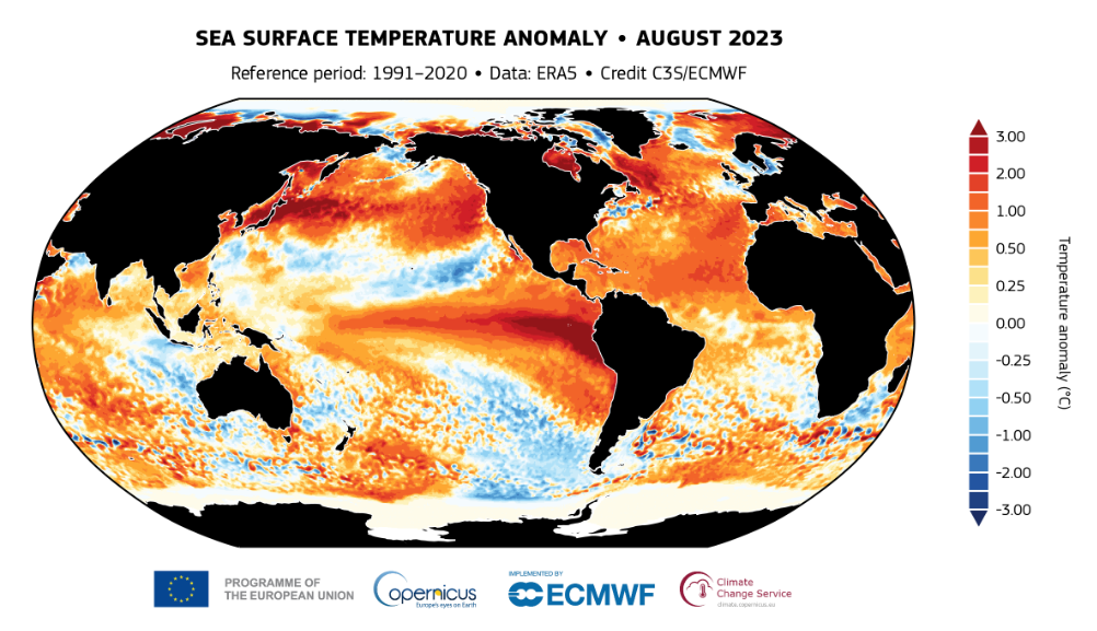
Figure 3 : Sea surface temperature anomaly (°C) for August 2023, compared with the 1991-2020 reference period (from: Copernicus).
In addition to accelerating sea level rise, ocean warming influences atmospheric circulation, which can lead to climate variations on a global scale. Combating ocean warming is therefore crucial to mitigating the impacts of climate change, including the increasing intensity of hurricanes and other natural disasters.
An intense Atlantic hurricane season
The intensity of this year’s hurricane season, even in the presence of the El Niño phenomenon, is attributable to the significant rise in ocean water temperatures, particularly in the Atlantic. In recent months, the water in the tropics of the Atlantic, where hurricanes start, has risen by around 2°C more than normal.
Hurricanes draw their energy from the oceans and convert it into violent winds. For a hurricane to develop, a water temperature of at least 26.5°C is generally required. The higher the water temperature, the more energy is available to intensify the storm. This increase in intensity is reflected both in higher wind speeds and in the amount of precipitation associated with the hurricane. It may also influence the size of the hurricane. Ultimately, all these factors can affect the intensity of the accompanying storm surge.
In early September, experts were keeping a close eye on Hurricane Lee, which was moving rapidly across the Atlantic Ocean. This hurricane had previously reached category 5, the highest on the Saffir-Simpson scale, used to measure storm intensity. At the time of writing, Hurricane Lee’s path may soon reach eastern Canada, and even Quebec.
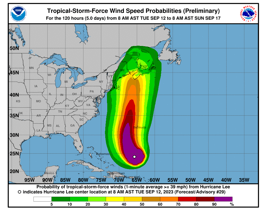
Figure 4 : Tropical-storm-force wind speed probabilities for Hurricane Lee for the next five days, between September 12 and 17, 2023 (from: National Hurricane Center and Central Pacific Hurricane Center, 2023).
Links between El Niño and the Atlantic hurricane season
The El Niño phenomenon we are currently experiencing should theoretically have reduced the frequency, number and intensity of Atlantic hurricanes. But that was not the case this year. The reason is simple: the increase in ocean temperature is offsetting the El Niño effect.
Rising ocean temperatures cause the atmosphere to warm, leading to an increase in atmospheric humidity. This combination increases the intensity of precipitation and the amount of energy available to fuel hurricanes. Ultimately, the increased intensity of these storms can cause major flooding due to heavy precipitation, resulting in significant property damage. They can also endanger human lives.
Understanding El Niño
El Niño is a natural climatic phenomenon that occurs periodically in the Pacific Ocean every 2 to 7 years. It is characterized by rising temperatures in the eastern Pacific Ocean, along the equator. This temperature increase, although modest (between 0.5 and 1°C), modifies planetary atmospheric circulation and thus has a major influence on the weather in many parts of the world.
Hurricanes in Quebec?
Due to warming seas and oceans, models suggest that hurricanes are moving into the Atlantic, increasing the risk for eastern Canadian provinces. However, the situation for eastern Quebec remains uncertain.
Rising sea levels are also a risk factor for coastal communities in the east of the country, as storm surges will be more dangerous. Increased precipitation is also expected to be a feature of these storms, heightening the risk of flooding in these regions.