
Modelling the risk of ice jams in southern Quebec in the context of climate change
This project will develop a predictive model of the risk of ice jams for a representative sample of southern Quebec watersheds in the context of climate change.
Project details
Principal(s) investigator(s)

Context
Ice jams occur almost every year in the rivers of southern Quebec. They are typically caused by mechanical ice breakup, which is a premature breakup that occurs when the water level rises suddenly and the strong current generates destabilizing forces that exceed the resistance of the ice cover. The ice fractures and fragments are dragged downstream. These fragments can then accumulate in a channel and create an ice jam.
Ice jams often cause high water levels and flooding. Ice jam flooding is a significant risk factor in Quebec, causing significant damage to infrastructure and property.
What’s more, climate change will affect the ice cover and hydrology of rivers in Quebec and the rest of Canada. That means the frequency, severity, seasonality and spatiality of ice jam risks could change in a future climate.
Currently, predicting ice jams is complex due the sudden nature of the events and the non-linear processes behind their causes. Moreover, the development of predictive models is constrained by the availability of ice jam observations, which are concentrated around the most populated rivers, leading to a detection bias that is difficult to correct for.
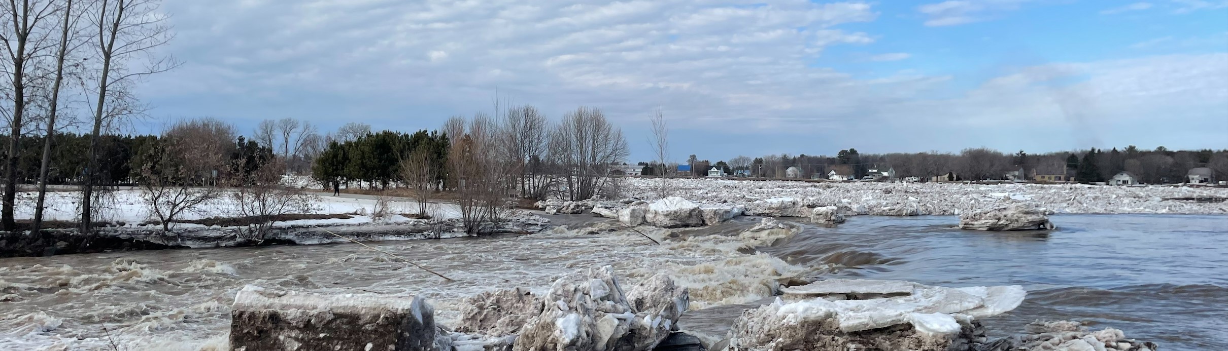
Photo credit: Lisane Arsenault-Boucher
This project is part of the QClim’Eau initiative, a collaboration between the Ministry of the Environment, Climate Change, Wildlife, and Parks (MELCCFP) and Ouranos.
Objective(s)
The general objective is to develop a predictive model of the probability of occurrence of ice jams for a representative sample of watersheds in southern Quebec, and to use this model to estimate the risks of ice jams in a future climate.
Methodology
The project is based on a model for predicting the daily probability of occurrence of ice jams developed for the Chaudière River at the Université du Québec à Trois-Rivières. The model will be recalibrated and validated for a larger sample of watersheds using historical observations, taking the detection bias into account, and using indirect indicators such as ice jam scars on trees along sparsely populated rivers. An ensemble of simulations from climate models will be input into the model to evaluate how the risk of ice jams will change in a future climate.
This project will have four phases:
Testing the transferability of the ice jam predictive model, which is calibrated for the Chaudière River, to other watersheds
Recalibrating a model applicable to a larger sample of watersheds
Developing indirect indicators of ice jams
Projecting the risk of ice jams in a future climate
Expected results
Tangible results:
A geospatial database of ice jam risk
Tables and graphs communicating the risk of ice jams
Identification of geomorphological factors conducive to ice jams
Publication of three scientific articles
Intangible results:
Training of highly qualified personnel
Development and consolidation of expertise on the risk of ice jams
Benefits for adaptation
Benefits for adaptation
The knowledge and tools developed by this project will help guide adaptation measures related to the risk of ice jams in the context of climate change in southern Quebec.
Funding
Other participants
Étienne Boucher, Université du Québec à Montréal
Martin Leduc, Ouranos
Karem Chokmani, INRS
716500