
IRENE : Radar imaging for water level estimation
By estimating water levels in ungauged areas, virtual stations contribute to the improvement of these essential tools. Based on free, easily accessible images, the approach will provide data on multiple sectors at an almost daily frequency and at little cost.
Project details
Principal(s) investigator(s)

Context
Floods are a recurring phenomenon in Quebec and, as with any extreme climatic event, the risk is likely to be influenced by climate change. It is in this context that Ouranos supports the INFO-Crue program (administered by the MELCCFP), which was created to optimize the delimitation of flood-prone areas in Quebec and to set up a real-time flood forecasting system. By using satellite radar images, which cover Quebec at an almost daily frequency and are available free of charge (thanks to Sentinel-1 and the RADARSAT Constellation Mission), the project aims in particular to meet the need for water level measurements in river sectors that are not gauged, by creating virtual measurement stations.
Objective(s)
-
To develop an operational satellite-based approach to create virtual water level stations from satellite radar images, without direct measurements taken in the field
-
To estimate water levels in ungauged sectors
-
To identify the spatial scope of application (optimal conditions and promising sectors) and detail the technical limitations of the method
-
To develop a prototype of an information technology-based tool to apply the method developed
This project is part of the INFO-Crue initiative set up by the MELCCFP.
Methodology
-
Establishment of the database (radar images, lidar data, validation data such as level and flow measurements, water lines during floods)
-
Selection of optimal sites for the development of the approach, i.e. sites that experienced flooding in 2019, for which validation data exists, which have sufficient satellite radar coverage and which have open banks and clear floodplains
-
Classification of the probability of water on radar images of optimal sites at 10 m spatial resolution
-
Disaggregation of this map using lidar data and the height above nearest drainage (HAND) model to obtain a map of water presence at 1 m spatial resolution
-
Estimation of water levels and validation of results at optimal sites
-
Calculation of uncertainty
-
Automation of process steps
Results
The initial methodology was based on the hypothesis that the probability of the pixels of a radar image (10mx10m) belonging to the water class could be translated into a percentage of open water. This hypothesis was tested using very high-resolution mapping data on the extent of the water, collected by drone. Unfortunately, this hypothesis was invalidated by comparing the fraction of water obtained by drone with the probability of the corresponding radar pixels belonging to the water class. Due to the challenges encountered, in consultation with representatives of the hydrologic expertise unit, the decision was made to not continue the development of an automated prototype, and instead to search for a new method and to further study the uncertainties and technical limitations of the method for estimating the level using radar images.
An alternative methodology was therefore developed and tested. It is based on the comparison of the extent of the water as determined by radar with the theoretical extents of water produced by binarizing the submersion maps by varying the values of the HAND model with 1 cm increments in order to determine the actual water level. This new method was applied to 14 sites that have a hydrologic expertise unit hydrometric station. The results were variable and depended on the characteristics of the site chosen. Two sites produced acceptable results, including one in Saint-Lambert-de-Lauzon, near hydrometric station 023404 (Figure 1). The two main characteristics of sites with acceptable results are that they had a wide range of water levels and they had open banks with a low slope, which allows for significant horizontal variations in the water body that are detectable by radar.
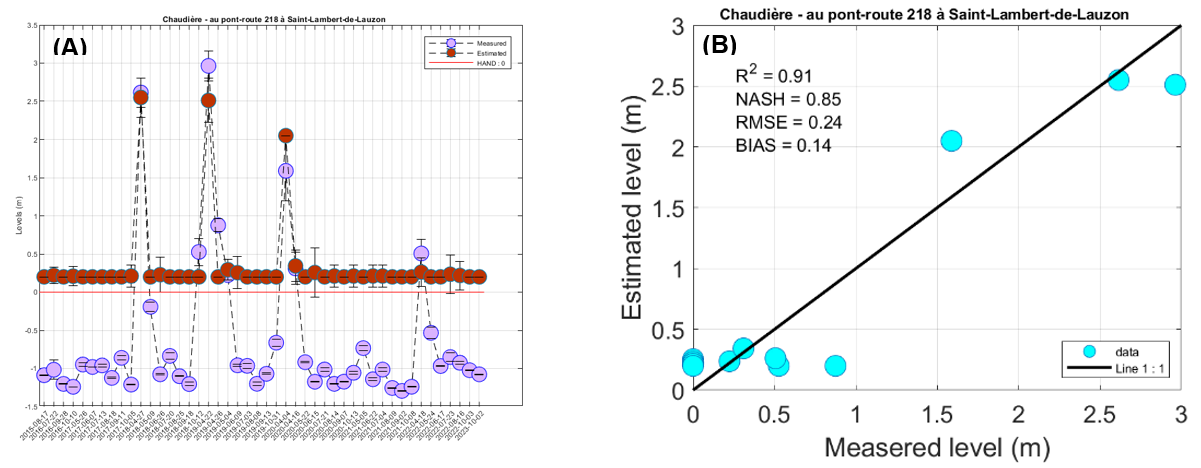
Figure 1. Comparison between water level modelling and in situ measurements for the Saint-Lambert-de-Lauzon station.
The results could be improved through the use of digital terrain models with low water levels, ideally complemented by bathymetry, in order to maximize the dynamics of the water levels observable on the radar images.
In addition, it would be beneficial to continue the project by applying the method at sites with ideal characteristics, regardless of the presence of hydrometric stations, using drone-generated digital terrain models and advanced classification techniques to process the radar images.
Benefits for adaptation
Benefits for adaptation
Integrated flood risk management will enable at-risk communities to adapt their behaviours and actions to reduce their vulnerability and increase their resilience to extreme weather events and climate change. Floodplain mapping and flood forecasting models are two essential tools for managing these risks.
By estimating water levels in ungauged river sections, IRENE virtual stations contribute to the development of these essential resources. As it is based on free, easily accessible images, this approach makes it possible to obtain this data in multiple places, at an almost daily frequency and at low cost.
Scientific publications
Funding
Related projects
705700