
Winds and storms
Wind is one of the fundamental elements of meteorology and climate. It is characterized by the movement of air relative to the earth’s surface. It can have significant effects on its environment, just as the environment significantly affects the wind.
Air movement depends on the rotation of the Earth, temperature contrasts and atmospheric pressure. Landscape features such as the presence of mountains, vegetation type and proximity to the ocean or a water body can also influence air movement.
Wind influences many aspects of human activity, while high winds can cause property damage and threaten people’s safety and even lives.
Beaufort scale
Wind force is classified according to the Beaufort scale, which shows the consequences and possible damage according to wind speed. At force 9 on the Beaufort scale, wind is described as a strong gale, reaching from 75 to 88 km/h. When it reaches a speed of 89 km/h, at force 10 on the Beaufort scale, it is considered a storm.
Storms with speeds from 89 km/h (force 10)
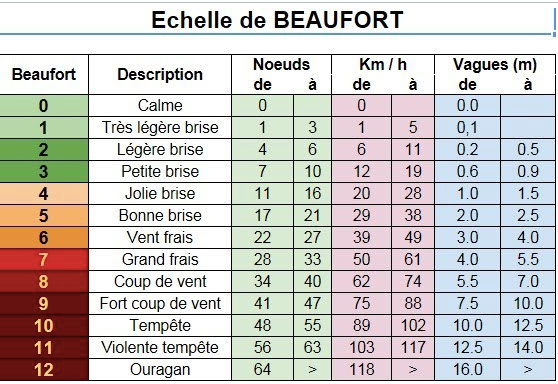
Figure 1 : Beaufort scale (from: Aquaportail, s.d.)
The influence of climate on winds and storms
Several weather phenomena, such as humidity, atmospheric pressure and temperature, have the potential to cause storm winds. While warnings and alerts may include criteria regarding heavy precipitation in the form of snow or rain, storms are defined by the strength of the winds generated. Thus, storms do not necessarily cause heavy precipitation, although they often do in Quebec.
Did you know?
In Quebec, it is difficult to isolate significant historic or future trends in terms of strong gales and storm winds. They are influenced by several factors, such as variations in ocean-atmosphere interactions and the North Atlantic Oscillation, which can vary on a monthly or even yearly basis. This makes it very difficult to identify clear trends over several years.
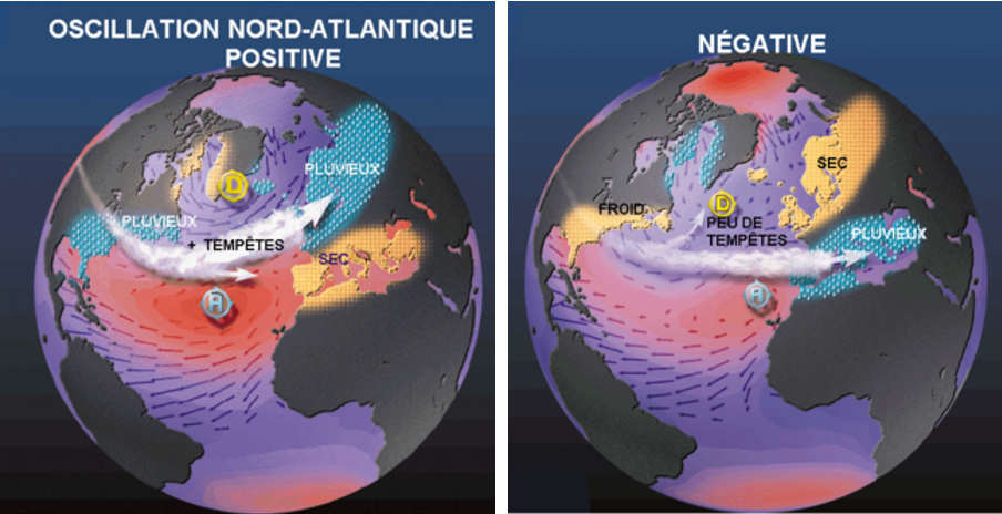
What is the North Atlantic Oscillation?
Source: Wikipédia
The North Atlantic Oscillation (NAO) is a climate phenomenon that affects the weather and climate system of the northern Atlantic Ocean. The NAO describes variations in the ocean-atmosphere interactions in this region. This phenomenon is characterized by changes in atmospheric pressure and in the intensity and position of the Azores High and the Icelandic Low, which have consequences for weather and climate systems in the region.
In general, trends indicate that a positive NAO is more conducive to storms and has the effect of causing rainier weather in Quebec. Conversely, when the NAO is negative, it results in few storms but colder weather in the province.
Types of storms
With frequencies that vary greatly from one weather phenomenon to another, Quebec’s strong winds can be generated by thunderstorms, low pressure systems, tropical storms and tornadoes.
Low pressure systems
Thunderstorms
Tropical storms
Tornadoes
Post-tropical storms
Low pressure systems
Low pressure systems are characterized by an asymmetric structure and rapid displacement. They generate precipitation and winds of various intensities. They occur throughout the year, but are more frequent and stronger between November and April.
Quebec is located at the confluence of three low pressure system corridors: the Atlantic coast, the American Rockies (mainly Colorado) and the Canadian Rockies (mainly Alberta).
The strongest winds are often associated with a cold front within a low pressure system. When low pressure systems reach the intensity of a storm, their passage over the St. Lawrence, when it is free of ice, produces a storm surge that raises water levels, which can be especially problematic at high tide.
Thus, in the coastal regions of eastern Quebec, storm surges add the risks of flooding and the aggravation of erosion to those engendered by strong winds and heavy precipitation.
Tropical storms
Tropical storms are characterized by a more symmetrical structure and slow movement, which increases their potential for damage. This type of storm brings extreme rainfall, high winds, huge waves and strong storm surges.
In the North Atlantic, they typically occur between June and November, although August and September are the most active. However, they are very rare in Quebec.
Hurricanes are tropical storms that are intense enough to meet the criteria set by the Saffir-Simpson scale.
The Saffir-Simpson scale
The Saffir-Simpson scale determines the intensity of hurricanes in the Atlantic Ocean and the Northeast Pacific. It classifies hurricanes into five categories based on maximum wind speed and assesses potential property damage.
Post-tropical storms
Post-tropical storms originate as hurricanes or tropical storms and change as they leave the tropics for higher latitudes. At that stage, they combine the characteristics of tropical systems, such as strong winds, torrential rain, high waves and strong storm surges, with the rapid travel speed of a low-pressure storm, allowing them to cause damage over a large area in a short period of time.
In Quebec, this form of storm occasionally affects eastern Quebec, namely the Gaspésie–Îles-de-la-Madeleine, Côte-Nord and Bas-Saint-Laurent regions. That happened in 2022, when Hurricane Fiona was felt in eastern maritime Quebec. In addition to further coastal erosion in these vulnerable regions, it caused considerable damage, particularly to infrastructure.
With the current state of knowledge, however, it is not yet possible to establish a link between the frequency and intensity of tropical storms in the North Atlantic and their potential to develop into post-tropical storms.
Thunderstorms
Thunderstorms are regularly experienced by Quebecers in the south of the province on hot and humid summer days. Thunderstorms are born of atmospheric instability produced by the meeting of a warm, moist air mass and a cold air mass. They exhibit lightning and thunder inside a huge cumulonimbus cloud.
As yet, there is no scientific consensus on any changes in the strength of violent winds associated with thunderstorms.
Visit "Thunderstorms and lightning in Québec" to learn more about these hazards.
Tornadoes
Tornadoes form inside very intense thunderstorm systems when the column of air rotates, forming a funnel. In Quebec, they occur mainly in the southwestern part of the province. For example, in 2018, the Dunrobin-Gatineau tornado generated winds with an estimated speed between 220 and 265 km/h. It caused a lot of damage and affected several hundred houses during its passage.
Compared to other types of storms, tornadoes are smaller in size and have a very short lifespan, but they are the most violent of all weather phenomena due to strong, rotating winds. In Canada, their intensity is determined by wind damage according to the Enhanced Fujita Scale.
Weather and climate models do not yet reach resolutions fine enough to simulate tornadoes. Since they are very localized and of very short duration, they often escape observation networks, meaning that their true number is greatly underestimated. Their numbers are biased toward inhabited areas because they are very often reported by the public.
The enhanced Fujita Scale
The Enhanced Fujita Scale (EF Scale) measures the severity of a tornado. It establishes a ranking of events based on the damage caused, on a scale of 0 to 5. Environment and Climate Change Canada uses 31 damage indicators to assess the effects of tornado winds. These indicators cover a wide range, including residential dwellings, office towers and trees. The wind speeds associated with the EF Scale range from 90 km/h (EF0) to over 315 km/h (EF5).