
Assessment of the Impact of Land Use Change on Climate – Phase 2
Many climate change adaptation and mitigation measures involve changes in land use, including urban planning, agricultural practices, the planting of trees or crops for bioenergy or carbon capture, and the restoration of natural ecosystems.
Project details
Principal(s) investigator(s)


Context
Land use changes alter energy and water exchanges between the atmosphere and the Earth’s surface. For example, converting a forest to agricultural land changes the reflectivity and rugocity of the surface, as well as its ability to retain and release water through evapotranspiration. These biophysical effects have a significant influence on the climate at the regional and global level. During the first phase of this project, called Forest–Herbaceous, the sensitivity of the CRCM5 to complete afforestation/deforestation was evaluated and compared with an ensemble of regional models. During this second phase, realistic land use changes will be considered. In particular, the emphasis will be on the relative contributions of greenhouse gas (GHG) emissions and land use changes consistent with the SSP1-2.6 and SSP3-7.0 scenarios.
This project was carried out in two phases.
Objective(s)
-
To generate land use maps consistent with the recent past, the present, and two future scenarios, and to implement these maps in the CRCM5.
-
To quantify the relative contributions of land use changes, GHGs and natural variability to present and future climates in North America and in Europe.
-
To identify the mechanisms responsible for the climate response to changes in land use.
-
To produce an ensemble of simulations to support the ClimEx II research project in collaboration with the Ludwig Maximilian University of Munich.
This project is part of the INFO-Crue initiative set up by the MELCCFP.
Methodology
-
In collaboration with colleagues at the GERICS centre in Germany, develop realistic vegetation maps for North America, as well as projections consistent with the SSP1-2.6 and SSP3-7.0 scenarios.
-
Produce CRCM5 simulations driven by ERA5 reanalysis over two domains, North America and Europe, with four vegetation coverages: past (1950), present (2015), and two consistent with 2100 in the SSP1-2.6 and SSP3-7.0 scenarios.
-
Produce CRCM5 simulations driven by four MPI-ESM members over both domains with five combinations of GHGs and land coverages (present, SSP1, SSP3).
-
Compare the climatology of the simulations driven by ERA5 in order to assess the impact of land use in the present climate, and then compare the relative contributions of GHGs, land use changes and natural variability using simulations driven by the MPI-ESM.
-
Compare the results of the CRCM5/CLASS simulations over the Europe domain with the ensemble of simulations produced by Land Use and Climate Across Scales (LUCAS) Phase II, which will have the advantage of incorporating several regional models.
Results
A set of 48 climate simulations was produced with CRM5 to quantify the effect of realistic land use changes in keeping with the SSP1-2.6 and SSP3-7.0 scenarios in North America and Europe. The first step in the analysis was to identify the main variables affected. For each scenario and season, we calculated the relative contributions of GHGs arising from land use changes. In general, the relative contribution of soils is greater for SSP1-2.6 than SSP3-7.0. This process also revealed that extreme temperatures were more affected than average temperatures. In terms of the energy balance, there are more subtle effects, but they are similar to the first phase of the project, i.e. radiant fluxes dominate the model’s response during the winter and spring while turbulent fluxes dominate in the summer. The water cycle is disrupted throughout the year, but mainly in the summer.
Forest cover, heat waves and water availability in Europe
Guided by the results of this work, Asselin et al. (2024) focused on the summer season in Europe for the SSP1-2.6 scenario. The most striking result of this analysis is the exceptional potential of afforestation to mitigate summer heat waves. Thanks to the large-scale afforestation of Europe in SSP1-2.6, heat waves are less intense in 2100 compared to today for about half of the European population (Figure 1). However, this heat attenuation comes from increased evaporation, which can cause concerns about water availability in more arid regions. Although the afforestation of Europe favours the recycling of rainfall, this additional water supply is not sufficient to compensate for the loss due to evaporation. As a result, on average across the continent, runoff decreases and the soil dries out.
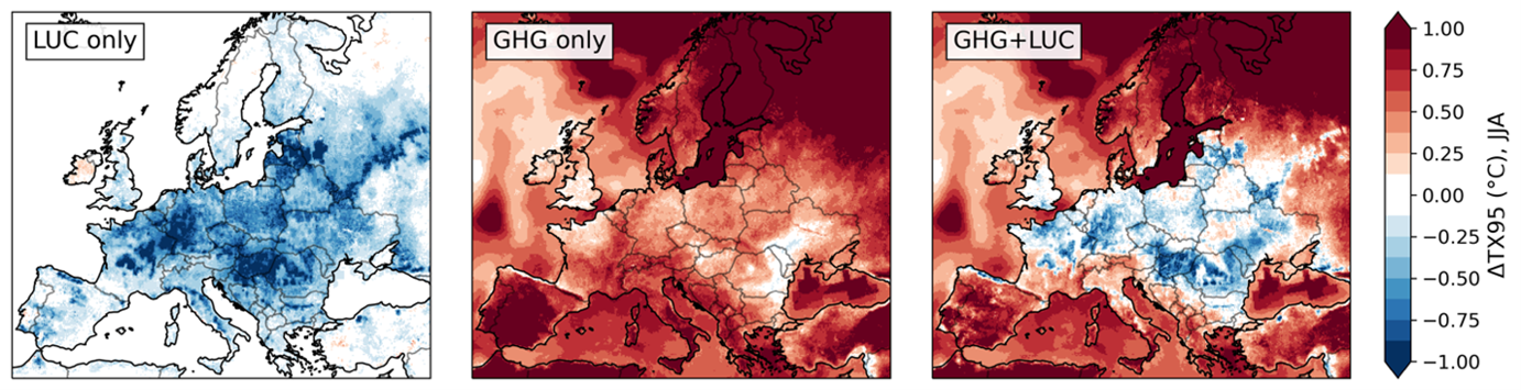
Figure 1. The effect of land use change (LUC), of greenhouse gases (GHG), and their combined effect on summer heat extremes, defined as the 95th percentile of the daily maximum temperature. The bluish regions in the right-hand panel show where the intensity of heat waves is attenuated at the end of the century compared to today.
New land cover maps for North America
Another major deliverable of this project is the publication of a land cover dataset for North America. These maps are available for each year between 1950 and 2100 for all major SSPs and can be used directly by a regional climate model (Figure 2).
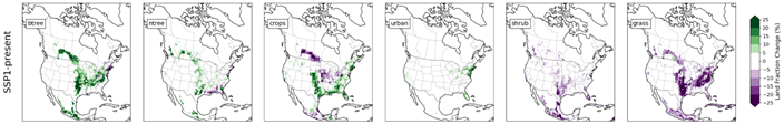
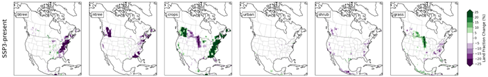
Figure 2. Land use change between 2015 and 2100 for SSP1-2.6 and SSP3-7.0, using the LANDMATE dataset (btree: deciduous trees; ntree: conifers).
Disruptions to the North American water cycle
Work is underway to better understand the relative contributions of GHGs and land use changes under SSP1-2.6 and SSP3-7.0, particularly on the east coast of North America. These two scenarios were chosen because they differ markedly in terms of land use: significant afforestation of the central and eastern part of the continent in SSP1-2.6, and massive deforestation of the east coast in SSP3-7.0 (Figure 2). Yet, the net evaporation, precipitation, and runoff are surprisingly similar in the two scenarios. An in-depth analysis suggests that the replacement of forests by crops in SSP3-7.0 also leads to an increase in evapotranspiration because rugosity due to vegetation is largely ignored by CRCM5-CLASS in mountainous regions. These results highlight the complexity of the effects of land use changes and the importance of understanding how they are accounted for by climate and surface models.
Benefits for adaptation
Benefits for adaptation
Several climate change adaptation and mitigation measures involve changes in land use, including urban development, agricultural practices, planting trees or crops for bioenergy or carbon capture, and restoring natural ecosystems. This project will help society anticipate the regional climate impacts of such actions, such as changes in precipitation patterns and temperature extremes.
The data produced will be used to inform hydrology studies where land use can have a major impact on water regimes, especially flooding.
Scientific publications
Funding
Other participants
-
Ralf Ludwig, LMU
-
Richard Turcotte, DEH
-
Nathalie de Noblet-duCoudré, IPSL
-
Diana Rechid, GERICS
-
Peter Hoffmann, GERICS
-
Vanessa Reinhart, GERICS
Related projects
706801