
Tools facilitating the analysis of climate-related infrastructure risks
This project will offer support for the process of prioritizing public infrastructure components in terms of vulnerability to climate change, based on evidence.
Project details
Principal(s) investigator(s)

Context
Adapting infrastructure to climate change often requires quantifying the risks associated with hazards such as extreme rainfall, high winds or heat waves. Existing guides and methodological approaches (ISO 31000; PIEVC Protocol) leave it up to practitioners to carry out the climate analyses required for their implementation themselves. However, estimating the probability of a climate hazard in the future (middle or end of the century) requires specialized expertise in climate science and access to vast data sets (the latest generation of climate projections, records from observation stations, and other recent climate data), which few organizations have.
Objective(s)
-
To facilitate access to the right climate information, in the right format, and make it easier to use for climate risk analysis purposes, by developing tools to estimate the probabilities of occurrence of various hazards that are relevant to infrastructure and influenced by climate change.
Methodology
Assess professionals’ needs in terms of future climate information for public infrastructure risk analyses
Establish a list of climate hazards and indicators with the help of an advisory committee
Calculate future climate indicators
Extract a threshold exceedance probability value
Develop software and run it on PAVICS (as well as data)
Develop and roll out a graphical interface
Results
The project enabled the development of post-processed climate projections, calculation services, and a prototype graphical interface that is accessible online, intended for professionals carrying out risk analyses for infrastructure. These resources are adaptable to the different risk analysis frameworks used in practice, and are applicable across Canada where data from stations is available. By explicitly taking climate-related uncertainties into account, the calculation service and the prototype provide the probability of exceeding a threshold of a climate hazard in future and historical climates. Additionally, complex indicators of extreme water levels and precipitation were developed and added to the platform. An advisory committee made up of a dozen members oversaw the project, and approximately sixty professionals were met with to evaluate the graphical interface.
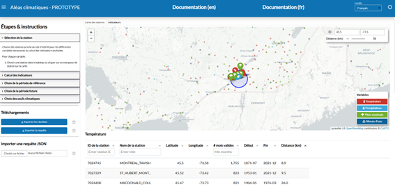
Figure 1: Landing page of the graphical interface.
The calculation tools are accompanied by examples provided in the project’s GitHub repository, as well as technical fact sheets explaining several concepts related to risk analysis that are accessible via the online prototype’s documentation.
The graphical interface is available on request. Please contact us by email for more information.
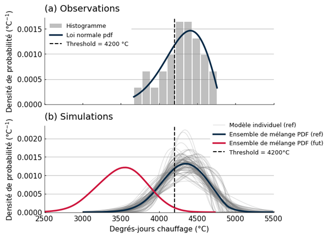
Figure 2: Examples of the probability of exceeding a threshold for heating degree days at the Montréal airport.
Benefits for adaptation
Benefits for adaptation
Recognizing the growing need for risk analyses in order to better develop, design and maintain infrastructure projects in Canada, the project will offer:
Straightforward access to probabilities for assessing the consequences associated with climate change
Support for the process of prioritizing public infrastructure components in terms of vulnerability to climate change, based on evidence
An innovative methodology for taking climate uncertainties into account in the calculation of safety margins as well as concrete examples of applications that will serve as inspiration and a methodological guide for professionals who are new to risk analysis
Scientific publications
Funding
Other participants
-
Institut national de la recherche scientifique - Eau terre
-
CBCL Limited
-
CLIMAtlantic
Related projects
710900