
Estimation of surges and higher sea levels at the outfalls of rivers located in the fluvial sector and maritime sector (estuary and gulf) of the St. Lawrence
The results of this project will produce a better estimate of flood risks and, consequently, better mapping of flood zones for regions where water levels in the receiving environment have a significant impact on flood risks.
Project details
Principal(s) investigator(s)

Context
The hydraulic modelling used to map flood zones requires boundary conditions, i.e. inlet flows and water levels at the outlet of the section. The modelling of flows from rivers and various ways to improve them are already being addressed by several INFO-Crue projects. However, taking water levels and the impact of rising sea levels in the St. Lawrence estuary and gulf into account is a new element that has been explored very little in Quebec. This project aims to provide the government of Quebec with the data needed to map flood zones at river outfalls influenced by estuarine and maritime phenomena.
More specifically, this study aims to provide an estimate of present and future water levels of the rivers included in the INFO-Crue work which have outfalls located in the fluvial and marine sectors of the St. Lawrence or along the Saguenay River, as illustrated in Figure 1. The project also aims to develop a methodology and provide expertise to the government to increase its knowledge in this area.
Objective(s)
-
Identify the appropriate datasets to allow the Quebec government to simulate compound flooding of the maritime and river environments in current and future climates
-
Develop a methodology to calculate the probability of compound flooding of rivers and the St. Lawrence for the outfalls targeted by INFO-Crue work
-
Prepare the required data for the maritime component of the technique identified in the previous point (e.g. annual maximums, recurrence intervals [T], average levels and the uncertainties associated with all these elements)
-
Analyze the impact of higher sea levels on water levels along the St. Lawrence, as well as on the frequency of compound flooding
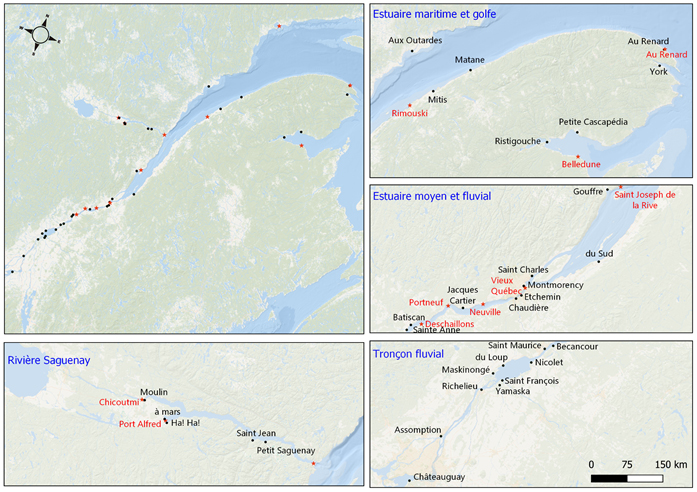
Figure 1. Location of outfalls used in the project (black circles) and tidal stations (red stars).
This project is part of the INFO-Crue initiative set up by the MELCCFP.
Methodology
-
Creation of a combined water flow/level dataset based on the annual maximums of one of these variables and the maximum of the other variable with an interval of ±1 day.
-
Evaluation of the correlation between the combined annual water level/flow maximums to determine if a relationship exists between the two variables and thereby identify the type of copula to be used for bivariate frequency analysis.
-
Non-significant correlation: no relationship between high flows and high levels (or vice versa). In this case, an independent copula is used and the compound flood risk is estimated using several equally probable water level/flow pairs associated with a given return period.
-
Significant correlation: the flood risk is based on the most likely water level/flow pairs (maximum likelihood) according to the most appropriate dependent copulae.
-
-
A bivariate frequency analysis taking into account the effect of rising sea level is then carried out in order to obtain an estimate of the expected impact of this phenomenon compared to the extremes of the current period.
Results
St. Lawrence Estuary and Gulf and the Saguenay River:
-
1. The dependence between extreme flows and water levels (with an interval of ±1 day) is low and statistically insignificant for all sections downstream of Québec City, as well as along the Saguenay. For that reason, bivariate frequency analysis using the independent copula was used to determine 7 equally probable Q-H pairs associated with recurrences of 2, 100 and 350 years, including water level and flow combinations recommended by FEMA in the United States.
2. Rising sea levels can significantly alter the combined return period and it is essential to consider them in coastal flood mapping. The comparison of the results produced with and without the effect of rising sea level shows that compound extreme events are expected to become much more frequent by the end of the century (Figure 2).
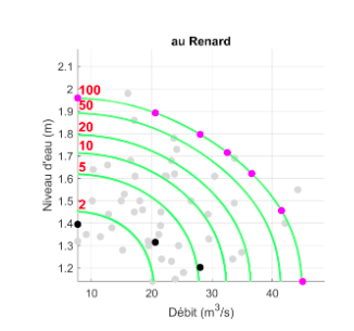
Figure 2. Isolines of 2, 5, 10, 20, 50 and 100 year compound floods for the combined series of maximum annual flows and maximum water levels with an interval of ±1 day, including the effects of rising sea levels at a time horizon of 2100. The scenarios selected at the outfall of the Rivière au Renard are identified in purple, while the black dots illustrate the same scenarios, but without the effect of rising sea level.
Fluvial sector (Québec City–Montréal):
-
The dependence between extreme flows and water levels is often statistically significant, especially upstream of Portneuf, where extreme water levels increasingly result from spring flooding of the St. Lawrence River rather than storm surges. For these outfalls, any delineation of flood zones that does not take into account the dependent correlation between the two phenomena could significantly underestimate the risk of flooding.
-
For outfalls where there is a significant correlation between extreme water flows and levels, dependent copulae are required for bivariate frequency analysis. The use of independent copula or the application of the approach proposed by FEMA in the United States would result in significantly underestimating the frequency of compound events.
-
The analysis shows that the impact of rising sea levels is greatest near Québec City and decreases non-linearly for upstream river outfalls. For example, for the Batiscan River, the 100-year historical compound event could become 5 times more frequent by the end of the century. According to current projections, the impact of higher sea levels is negligible for the outfalls located upstream of the Saint-François River (Figure 3).
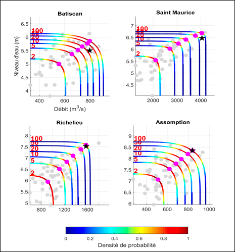
Figure 3. (Multicoloured lines) Isolines of the compound flooding for 2, 5, 10, 20, 50 and 100 year return periods of the series of maximum annual flows and maximum water levels with an interval of ±1 day, including the effects of rising sea levels at a time horizon of 2100. The Q-H pairs corresponding to the maximum likelihood are identified by pink circles while the black stars illustrate the same points, but without the effect of higher sea levels. The grey circles show the combined dataset.
Benefits for adaptation
Retombées pour l'adaptation
The results of this project will produce a better estimate of flood risks and, consequently, better mapping of flood zones for regions where water levels in the receiving environment have a significant impact on flood risks.
This project made it possible to obtain an initial quantification of sea level effects between Québec City and Montréal, and enabled the inclusion of this phenomenon in the evaluation of the compound flood risk for the fluvial, estuarine and maritime sectors. These results are particularly interesting given that the impact of rising sea levels in Quebec remains little explored, particularly along the St. Lawrence River.
Moreover, the project developed expertise, in particular among Quebec government engineers, on bivariate analyses and on the consideration of water levels in the receiving environment in frequency analyses.
Scientific publications
Funding
Other participants
-
Jean-François Cyr, DEH
-
Richard Turcotte, DEH
-
Edouard Mailhot, DEH
-
Hind El Housni, DEH
-
Louis-Philippe Caron, Ouranos
-
Gabriel Rondeau-Genesse, Ouranos
Related projects
705300