
Sea level rise
Globally, the most recent data indicates that the mean sea level rise could reach between 0.63 and 1.01 metres by 2100. This rise may even be as high as 2 metres if we consider the processes associated with the melting of the ice caps.
Although climate projections from CMIP6 are not yet available for sea level rise, everything leads to believe that the rise in mean sea level will be accentuated compared to the CMIP5 projections, particularly due to the accelerated melting of Greenland.
Projected changes in Quebec
In Quebec, the rise in average sea level is reflected in different ways, with variations depending on the region of Quebec. In the Magdalen Islands, climate projections indicate that the relative sea level could reach between 1.41 m and 1.60 m by 2100.
On the other hand, a less marked increase is projected in the Bas-Saint-Laurent and Côte-Nord regions, and even less in the regions surrounding Québec City.
In Nunavik, Hudson Bay may be fairly stable or even a drop in relative sea level. The regions surrounding Ungava Bay could see a rise of between 0.4 and 1 m.
To access finer-scale data,
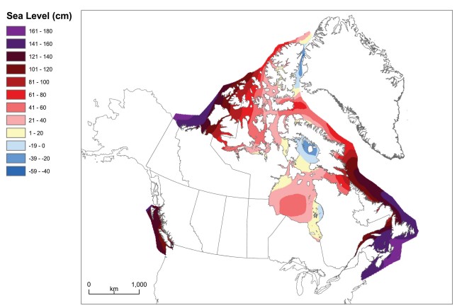
Figure 1: Projected relative sea level in 2100 for the high scenario, which predicts an additional 65 cm of sea level rise from West Antarctica added to the RCP8.5 median. The projection is relative to the average conditions from 1986 to 2005.
Storm tide increases
The gradual rise in sea level, combined with low-pressure systems, could lead to an increase in the frequency and intensity of storm surges and cause an increase in the risks associated with coastal erosion and submersion.
When post-tropical storm Fiona hit the Magdalen Islands in September 2022, a storm tide at least 1.22 metres high accompanied by waves 6 to 8 metres high caused coastal submergence in several locations.
Definition | Storm tide
Storm tide refers to the height of water when it rises above the expected tide level during a storm surge.
Return to the observed changes
Consult the impacts of sea level rise
Last update of the page: May 2025.