
For the past few months, various meteorological organizations have been suggesting that an El Niño episode, or even a “super El Niño,” will develop over the course of this year.
As global temperatures continue to break records, the possible return of this natural phenomenon could amplify the ongoing global warming. The consequences may be significant, including large-scale climate disruptions.
What would the emergence of a new El Niño mean for a global climate that’s already changing?
What is El Niño?
El Niño is the warm phase of an irregular cycle called the El Niño–Southern Oscillation (ENSO). This cycle is defined by a temperature oscillation at the surface of the equatorial Pacific Ocean. This temperature increase (in the case of El Niño) can lead to significant changes in precipitation and temperature in several regions of the world due to its impact on the Earth’s atmospheric circulation.
Learn more :
The evidence is mounting: An El Niño event is forming
After the La Niña phase in 2025 and early 2026, the ENSO forecast models now agree that an El Niño will form in the coming months.
At present, the only question that seems to remain unanswered regards its intensity. There is a barrier to the prediction of El Niño in the spring which limits the ability of models to predict the state of the ENSO too early in the year. Now that this barrier is behind us, confidence in the predictions by the different models is gradually increasing. But what do they tell us?
Before answering this question, it’s important to remember how the intensity of an El Niño episode is defined. Climatologists say that an El Niño is in progress when the temperature in the equatorial Pacific is 0.5 °C higher than the average. Its intensity can be classified according to the magnitude of the temperature anomaly observed:
Between 0.5 °C and 1 °C: Weak El Niño
Between 1 °C and 1.5 °C: Moderate El Niño
Between 1.5 °C and 2 °C: Strong El Niño
Although the expression “super El Niño” is not a standard scientific term, it generally refers to an El Niño episode with a temperature anomaly over 2 °C.
So, what do the latest model-based predictions say?
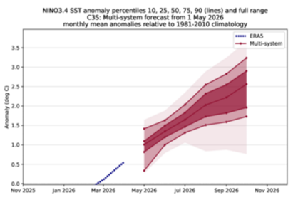
Figure 1: C3S multi-system forecasts for the anomaly in the Niño 3.4 index. The lines indicate the 10th, 25th, 50th (median), 75th and 90th percentiles. The temperature anomaly is calculated relative to the climatology of 1981-2010. (From: Copernicus, 2026.)
As the figure shows, several models predict a temperature anomaly exceeding 2 °C, and some even go beyond 3 °C. Depending on the temperature anomaly that is actually reached, this El Niño could become the strongest one observed in a long time.
If the temperature anomaly reaches 2.5 °C, it would be a throwback to the episodes in 1982-1983 and 1997-1998. According to a recent study, these episodes led to estimated economic losses of $4.1 billion and $5.7 billion worldwide, respectively. These losses were caused by devastating floods, droughts that destroyed crops, and a resurgence of tropical diseases.
If the anomaly exceeds 2.5 °C, as some models suggest, it will be a historic episode, with no equivalent in recent observations. In general, the higher the intensity of an El Niño, the greater its impacts.
In Canada, El Niño generally results in warmer winters in the western part of the country. The phenomenon generally has little influence in Quebec.
Record heat due to the combined effect of El Niño and global warming
El Niño acts as a heat amplifier on a planetary scale. It is largely responsible for the fluctuations that punctuate the steady rise in average global temperatures. It also adds to the general warming trend already caused by human activities. The result: when the two are combined, global temperatures tend to rise even further.
2023 and 2024 are a good example of this. Both were marked by record heat that was partly attributable to El Niño. 2024 has also been designated as the hottest ever recorded, with global average temperatures exceeding the threshold of +1.5 °C (compared to the pre-industrial era) for the first time.
The outlook for this year and those to come is in line with this. As of the beginning of the year, Environment and Climate Change Canada predicted that 2026 would be one of the hottest years ever recorded, with a projected global average temperature around +1.44 °C, comparable to what was seen in 2023 and 2025.
However, the confirmed development of a new El Niño episode could accentuate this trend and make 2026 the second hottest year ever recorded. Some experts even fear that it could become the hottest ever, surpassing the record set in 2024.
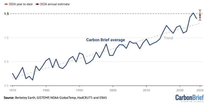
Figure 2: 2026 is on track to be the second hottest year ever recorded. The time series represents the average global temperature relative to the average in 1850-1900. (From: Carbon Brief, 2026.)
The importance of adapting
Beyond a possible El Niño episode, which could temporarily accentuate the rise in global temperatures and increase certain climate risks, the underlying trend remains unequivocal. The climate is warming permanently and its effects on societies, economies and the land are already being felt.
This points to a dual imperative. We need to not only reduce greenhouse gas emissions, but also accelerate the implementation of adaptation measures.
In real terms, this means rethinking human systems today —including living environments, food systems, water availability and the economy—so that they are designed to handle the changing climate. All of this will strengthen our collective resilience.